Routes
As native Colombians and adventure enthusiasts, we have created routes for you.
Important for route planning:
Understanding the Terrain
Colombia is a country that is as diverse as it gets: culture, food, landscapes, and nature. This extreme diversity is not only exciting but also a challenge for planning. To better understand the country, you need to understand the different regions of Colombia:
- Andes - Central Colombia: Here, 75% of the population lives. You will find tropical dry forests, tropical rainforests, highlands, vast lowland and highland valleys, and even a small desert as well as snow-capped volcanoes in the famous coffee region, known for the best Arabica you can get.
- Caribbean: Along the coast, which Colombians mostly refer to as the hot and dry region, you will find beautiful beaches, the world's largest maritime mountain range, Colombia's largest desert, and the largest fortifications that the Spaniards built on the American continent.
- Orinoco: The plain that borders Venezuela in eastern Colombia is the Guyana Shield, one of the oldest geological formations in the world, which starts where the Andes end and stretches to the Atlantic. Half of the year, this region is flooded, so it is no wonder that it has the world's largest amphibian diversity. There are also the largest rock art sites in America, some of which are 12,000 years old.
- Amazonas: The jungle. Although Colombia has an important part of the Amazon rainforest, it is only accessible by car from the far south. Let Mocoa be your gateway to the jungle.
- Pazifik: When it rains, it pours: Colombia is also the rainiest place on earth with almost 10,000 mm of rain per year. Looking for a literal rainforest? Here it is! And the icing on the cake: whale watching from July to November.
Planning time
Once you have decided on the region you want to explore, plan 1-2 weeks for each region. Depending on the available time, you will get a good idea of which regions you want to visit.
Important note
Traveling by camper requires flexibility as there may be road closures, repairs, or mudslides. Don't plan every day, but leave some days for the unexpected - whether it's a closed road or a place you like so much that you want to stay longer.
Adventure guaranteed: Exciting routes through Colombia
-
-
 Roadtrip Cundiboyacense
- Catedral de Sal in Zipaquirá - Colombia's first wonder of the world
- Guatavita - on the trail of the legend of El Dorado
- The second highest lake: Tota Lake with turquoise water at "Plays Blanca
-
 Roadtrip Desierto Tatacoa
- A Road Trip through the Tatacoa Desert & Los Hoyos
- Enjoying star showers at the observatory
- San Agustín with great landscape & culture
-
-
-
 Route Wildcamping in Altiplano + Llanos
- Wild Camping & Adventure Route
- Drive from Bogotá around Lake Tominé & El Dorado
- Llanos Landscape
- Past the traditional villages of Tota, Pesca and Toca
-
 Route Santander
- Barbosa with parks, rivers and gourmet restaurants
- San Gil - the adventure capital of Colombia
- Barichara as one of the most beautiful colobial towns in the country
- Mesa de los Santos & Stop at Chicamocha National Park
-
FAQ
-
Where can we stay overnight?Maway has a large network of campsites. Depending on your route, you can decide flexibly where you want to stay overnight. These include private campsites such as parks and farms, as well as public places such as gas stations, viewpoints, and special nature sites, which are sometimes free of charge.
-
Are there set routes?In principle, you can choose your own route and travel as flexibly as possible. We have already put together a few routes for you as inspiration.
-
Am I allowed to leave the country?No, this is not possible due to insurance coverage.
-
What is the minimum rental period?The minimum number of rental days depends on the specific vehicle. Check out our campers here.
Route through the Cundiboyacense Plateau
DAY 1
Your route starts in the north of Bogotá. On the way to your first destination, you can make a stop in Zipaquirá. Here you will find the Catedral de Sal, also known as the Salt Cathedral - an impressive Catholic church built 180 meters underground in a salt mine and considered an artistic and architectural gem and also referred to as the first wonder of Colombia. About an hour away from the Salt Cathedral is Guatavita, a city with a significant history - because here is the legendary Laguna de Guatavita, a beautiful emerald-green lake where the legend of El Dorado takes place. Between the communities of Guatavita and Sesquilé is the Tominé reservoir, where there are two recommended campsites for the first night.
NIGHT 1 - Tominé Reservoir
1. Camping Arjona
- Location: Between Sesquilé and Guatavita, on the shore of the Tominé reservoir, near the Club Naval Marina de Guatavita.
- Climate: Cold
- Amenities: Toilets, showers, hot water, green areas, restaurant, electricity, Wi-Fi, kayak, sailboats, boats, jet skis, campfire, picnic, grills, games, rackets, balls, hammocks, and Frisbee
- Contact:
- Instagram: @camping_arjona
- Phone: (+57) 3053988234
2. La Chala Guatavita
- Location: 3 minutes from Guatavita, with a splendid view of the Tominé Reservoir and the countryside.
- Climate: Cold
- Amenities: Toilets, shower, hot water, green areas, lake view, pet-friendly, space for campfire
- Contact:
- Instagram: @lachalaguatavita
- Phone: (+57) 3138545963
DAY 2
After breakfast with a view of the reservoir and an hour's drive with splendid views, you reach Puente de Boyacá, a small bridge declared a national cultural heritage site with a great history: Here the last battle was fought that brought Colombia final independence. Before reaching your second destination, it is advisable to make a detour to Ráquira, which offers its visitors a true spectacle of colors: the entire city presents itself in bright, intense colors - both the houses, the balconies, and the handicrafts. Ráquira is considered the capital of pottery in Colombia. Then, a half-hour drive will take you to the community of Villa de Leyva, which is one of the 17 Colombian cultural heritage cities. With its stone streets, white facades, colonial houses, and flower gardens, it is one of the most beautiful towns near Bogotá. You should definitely visit the Chocolate Museum, Pozos Azules, the Gondava Dinosaur Park, Casa Terracota, the Aventura Park, and also worth visiting are a jeep tour and a night visit to the central square. It's worth spending more than two days in this magical place.
NIGHT 2 – Villa de Leyva
Camping San Jorge
- Location: 7 minutes from the main square of Villa de Leyva.
- Climate: Cold
- Amenities: Toilets, shower, hot water, green areas, dishwasher, board games, playground, pet-friendly.
- Contact:
- Instagram: @campingsanjorge
- Website: www.campingvilladeleyva.com
- Phone: (+57) 3112131125
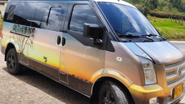
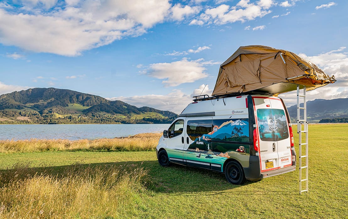
Our campers are just the thing for the perfect off-road trip with guaranteed adventure. These two models in particular are ideal for this route:
Orquidea Camper
If you are looking for luxury and comfort, the Orquidea Camper is just right for you.
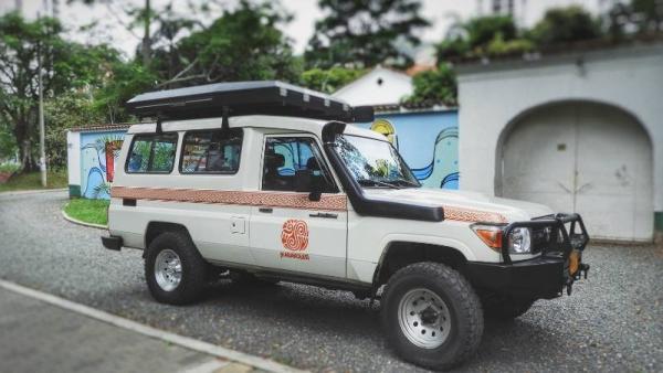
Nomada Camper
The Nomada is the ultimate all-rounder, combining the best of both worlds. With its 4x4 capabilities, it conquers diverse terrains with ease. Inside, the camper module in the rear offers exceptional comfort and space.
DAY 3
From Villa de Leyva, you will drive an hour and a half to the municipality of Paipa, which is part of the Ruta Libertadora and has gained historical significance through the Battle of Vargas Swamp. The corresponding monument is an absolute must-see in Paipa. The Sochagota Lake is also located here, which contributes to the biodiversity of the central region of Boyacá as an important ecosystem. Other noteworthy attractions in Paipa are the famous thermal baths, the ecological Atisbe Park, the Manoa recreational park, and the Laguna Seca nature reserve.
NIGHT 3 – Paipa
Campsite: Tacama Camping
- Location: 5 km from Paipa.
- Climate: Cold
- Facilities: Toilets, shower, hot water, restaurant, board games, mini soccer field.
- Contact:
- Instagram: @tacamacamp
- Website: www.tacamacamping.com.co
- Phone: (+57) 3016456132
DAY 4
After breakfast amidst the pristine nature, you will reach Duitama, just 15 minutes from Paipa. Here you should definitely visit Pueblito Boyacense, an architectural gem with about 100 houses spread over seven blocks, each representing a municipality of Boyacá. After a 25-minute drive, you will reach the municipality of Nobsa, the capital of the so-called Ruanas - Colombian ponchos, which you can buy there in the best quality. After a half-hour drive, you will be in the municipality of Monguí, which is part of the Colombian cultural heritage network. At this very idyllic place, great discoveries await you at every street corner amidst the Colombian nature. In another hour, you will reach the town of Firavitoba, which is known for its colonial architecture, but existed as an indigenous village before the conquest and has a lot of history to discover. There, you will find the campsite for the next night amidst the mountain landscape of Boyacá.
NIGHT 4 – Firavitoba
Campsite: Landhaus Glamping
- Climate: Cold
- Facilities: Toilets, shower, water, green areas
- Contact:
- Instagram: @landhausglam
- Phone: (+57) 3222175248
DAY 5
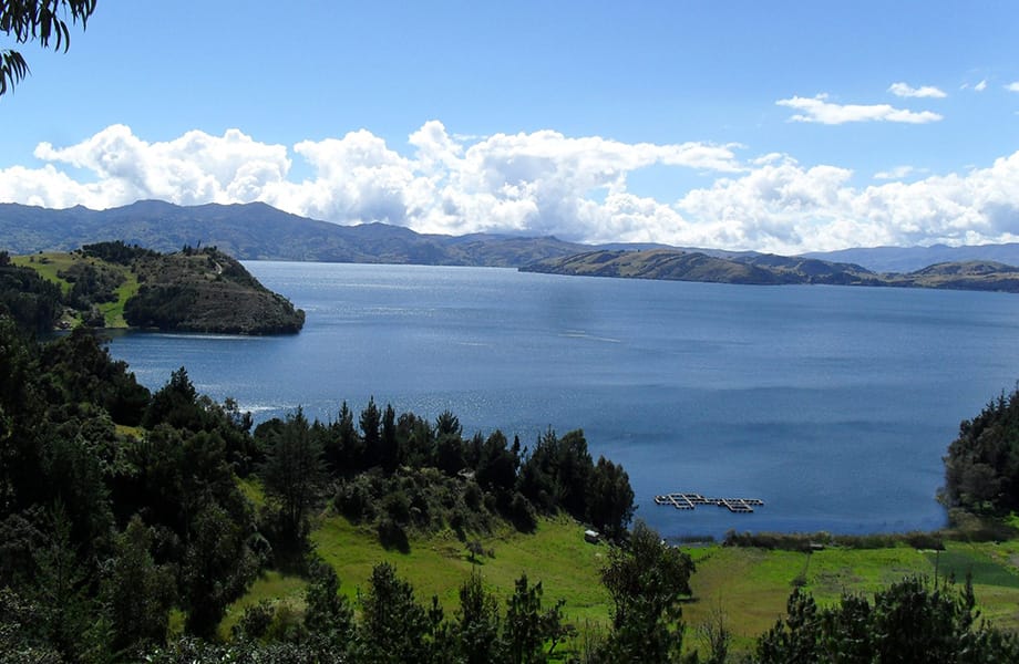
After a 10-minute drive through the mountain scenery, past numerous green meadows where sheep graze, you will reach the village of Iza. The lively history of this small town is reflected in its rock paintings, myths, traditions, festivals, and colonial architecture. Iza is also known for its delicious sweets. Your route will eventually lead you through the small town of Cuitiva, which is just over half an hour away, to Lake Tota, Colombia's largest natural body of water and the second-highest lake in South America after Lake Titicaca. There, you will find turquoise water and an incredible white sand beach called "Playa Blanca," a Caribbean wonder in the middle of the Colombian Andes. Spend the next night on a hill near the lake or on the lakeshore.
NIGHT 5 – Lake Tota
1. Campsite – Camping El mirador del Lago de Tota
- Location: 5.5 km from the village of Cuitiva. On a hill by the lake with a viewpoint. 25 minutes from Playa Blanca.
- Climate: Cold
- Facilities: Toilets without showers, green areas, restaurant, electricity, water.
- Contact:
- Instagram: @elmiradordellagodetota
- Phone: 3108843264 - Abdenágo
2. Campsite – Arcoiris del Lago
- Location: 13.6 km from the city of Cuitiva. Directly on the shore of Lake Tota, 5 minutes' walk to Playa Blanca.
- Climate: Cold
- Facilities: Bathrooms without showers, water for refilling tanks, green areas, restaurants, electricity
- Contact:
- Instagram: @arcoirisdellago
- Telefon: (+57) 3208563469 – Javier
Recommendations
The climate on this route is very cold. Therefore, we recommend wearing warm clothes, but don't forget your swimwear, as the thermal baths in Paipa are worth a detour. By the way, if you want, you can also swim in Lake Tota.
Route through the Tatacoa Desert
DAY 1
After starting in Bogotá, your first drive takes you 125 km to El Espinal, ideal for a first stop and breakfast. There, don't miss out on the typical Colombian tamales and the famous Avena Tolimense. Afterwards, a walk through the city to the Cathedral and the main square is recommended. Another typical attraction of this beautiful community is the Parque Mitológico, a park where local myths and mythological figures are depicted, such as the Patasola and the Mohán. To finish and for the road, we recommend that you take the typical quesillos wrapped in banana leaves with you.
An hour away from Ibagué is the Camping Tacuara, where you can spend the first night, rest, and enjoy the warm weather. The next day, it is worth visiting the viewpoint of Martinica, from where you have a spectacular view of the Tolima mountains and nature.
NIGHT 1 - Ibagué
Campground: Camping Tacuara
- Location: Between El Espinal and Ibagué
- Climate: Warm
- Facilities: Toilets, showers, restaurant, electricity, Wi-Fi, pet-friendly.
DAYS 2 and 3
After 204 km and about 3 hours of driving, you reach the city of Neiva, which is considered the capital of the Río Magdalena and offers you numerous destinations full of nature, culture, and tradition.
A walk along the Malecon on the Río Magdalena should not be missed. There is the Monument La Gaitana, which represents the resistance of the indigenous people against the conquerors. In the city center, the Cathedral of the Immaculate Conception and the architectural design of the Dian building are worth seeing. In June, the Festivals of San Juan and San Pedro are celebrated, where the Reinado Nacional del Bambuco (National Bambuco Competition) is a tradition. Before leaving Neiva, be sure to drink a fresh cholupa (passion fruit) juice.
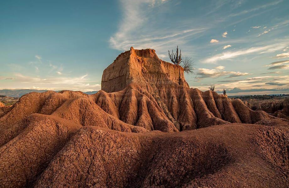
A 44 km drive takes you to the Tatacoa Desert, where you can hike on the paths of reddish earth and feel like you have entered another planet full of cactus species. Explore the Valle de los Fantasmas with its ghostly sand formations and take a bath in the natural pools known as Los Hoyos. At night, a visit to the astronomical observatory is recommended, where you learn how to read the sky and enjoy the starry sky.
In the Valle de los Deseos, the "Valley of Wishes," you can stack stones and send a wish to nature. It is said that if the wind blows the stones around, a wish has been granted. Refreshment is provided by a cholupa slushie in the village of Villavieja.
NIGHT 2 and 3 – Tatacoa Desert
Campsite: Estadero Sol de Verano
- Location: 3 minutes from the Observatory.
- Climate: Warm
- Facilities: Toilets, showers, restaurant, electricity, Wi-Fi, pet-friendly. There is no electricity at night to avoid light pollution and allow for better stargazing. Bring insect repellent.
- Contact:
- Instagram: @soldeveranodonalilia
- Phone: (+57) 310 4916154
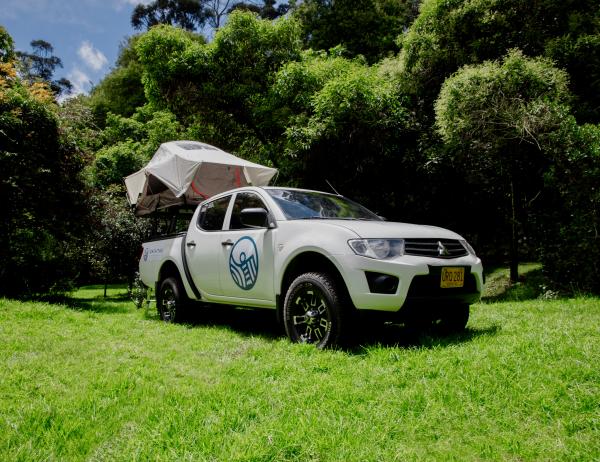
Effortlessly through deserts and moors - we know which campers will get you there. Currently with a discount on our vehicles for this route. See for yourself:
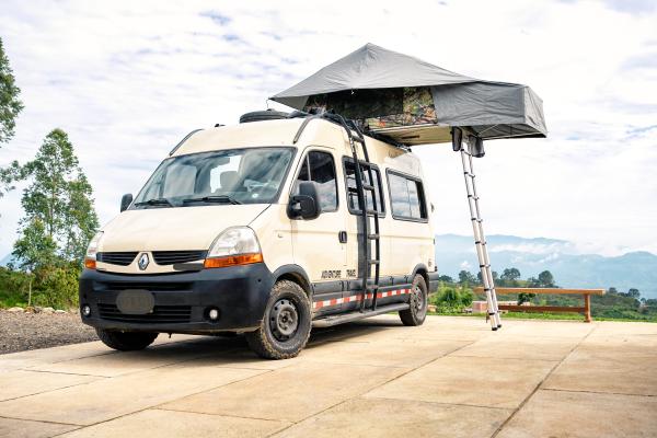
Tayrona Camper
For adventurers and off-road enthusiasts, the Camper Tayrona is the perfect companion that takes you anywhere in Colombia.
Parcerita Camper
Discover the captivating exterior design of the Parcerita campervan and embark on an unforgettable journey through Colombia's most renowned destinations.
DAY 4 and 5
After 85 km, you will reach the Betania Reservoir with its dam, which controls the flow of the Magdalena River and is one of the main sources of energy in the region. The Water Festival is also held there. The lake is also great for water sports such as jet skiing and canoeing in traditional colorful canoes or boats. You can also visit the lake's islands, such as the "Cueva del amor". Alternatively, a 3-hour hike or horseback ride is recommended.
Fishing is also popular at the reservoir, as it is home to the largest breeding ground for red tilapia and mojarra fish in Colombia.
Don't forget to visit the central square of the Yaguará and Hobo communities near the dam.
After 94 kilometers, you will reach the town of Garzón, known as the soul of Huila. The San Miguel Arcangel Cathedral has beautiful and characteristic architecture. 18 km away on the same route is Salto de las Damas, known for its beautiful waterfall where you can take a swim.
Pitalito is 85 km from Garzón and is the second most important municipality in Huila, worth a stop on your way to San Agustín. Pitalito is one of the main coffee producers, known for its crafts, and their Achiras - a traditional salted pastry that you must try.
Laguna de Guatipán is 40 minutes from Pitalito in the midst of a breathtaking natural setting. The National Park Cueva de los Guácharos is also located there, but it is quite remote - an ecological hike to the park is worth it for a longer stay in this community.
Finally, you will arrive in San Agustín, which is 33 km from Pitalito. The landscape, archaeology, and ancient culture of this community will captivate you. It is known for the San Agustín Archaeological Park, listed as a UNESCO World Heritage Site, where you will find numerous religious monuments and pre-Columbian stone sculptures, one of the main sites of the prehistoric San Agustín culture. You can also visit other temple sites and tombs at the Museum of the Archaeological Park, located in the community of Obando, 15 km from San Agustín.
From the village of Pradera, which is 23 km before San Agustín, you can take an ecological hike to the Los Tres Chorros waterfalls. There, you can take a swim and catch glimpses of local animals such as capuchin monkeys.
NIGHT 4 and 5 – San Agustín
Campsite: Buena Vista
- Location: 10 km from San Agustín, on the road to the archaeological park, surrounded by nature.
- Climate: Warm
- Facilities: Toilets, showers with cold water, water refill station, green areas, Wi-Fi, pet-friendly, restaurant.
- Contact:
- Facebook: facebook.com/agencialasmoyas
- Phone: (+57) 311 2220097
Route Santander
Day 1: Barbosa
You start the journey from Bogotá towards Barbosa, which is about a 3-hour drive. Barbosa is a destination where you can enjoy various parks, rivers, swimming pools, and restaurants to have fun with family, friends or your partner. Moreover, the climate here is mild - with an average temperature of 22 degrees Celsius. Are you a foodie? Don't miss the opportunity to try local dishes like "Carne Oreada" (dried meat) and "Mazamorra" (corn pudding).
Night 1 - Barbosa
Campsite: Recrear Gaia – Finca la Arabia
- Campingplatz: Recrear Gaia – Finca la Arabia
- Location: Between Barbosa and Moniquirá.
- Facilities: Bathroom, shower, green areas, restaurant, electricity, swimming pool, table tennis, game room, laundry service, pet-friendly.
- Contact:
- Instagram: @centrorecreacionalgaia
- Phone: (+57) 3166294765
Day 2: San Gil
On the second day, you can continue your journey towards San Gil, which is about a 2-hour drive from Barbosa. San Gil is the adventure capital of Colombia. In the surroundings, you can practice rafting, spelunking or paragliding. It is famous for its wonderful landscape, as San Gil is surrounded by deep canyons, flowing waters, waterfalls, and mountains, and we cannot fail to mention some cute colonial towns in the vicinity. The local cuisine in San Gil includes dishes such as Hormigas Culonas (roasted ants) and Mute Santandereano (a hearty soup with pork and plantains).
Night 2
Campsite 1: Condado de Casa Grande
- Location: Via San Gil - Curiti, Km 5.
- Facilities: Bathroom, hot shower, large green areas, restaurant, swimming pool, children's games.
- Contact:
- Instagram: @condadodecasagrande
- Phone: (+57) 3157553891
Campingplatz 2: Monkey Trip Hostel
- Location: 6 blocks from the main park of San Gil
- Facilities: Bathroom, shower, hot water, fully equipped kitchen, laundry, Wi-Fi, playground, bar, swimming pool and the best hostel atmosphere full of friendly people ready to help you with your itinerary for activities in San Gil.
- Contact:
- Instagram: @tripmonkeyhostel
- Phone: (+57) 3043110734 Juan Diego Moncayo
Day 3: Barichara
Barichara On the third day, you can drive from San Gil to Barichara, which is about a 30-minute drive away. Barichara is one of the most beautiful colonial towns in the country with cobblestone streets, picturesque landscapes, white buildings with red tile roofs, colorful shutters, and a relaxed atmosphere. El Mirador, also known as the viewpoint, is one of the best places in town from where you can admire the wonderful area where Barichara is located. Barichara is located on the edge of the Suarez Canyon, so the scenery from here is absolutely breathtaking.
Night 3 - Barichara
- Campsite: : Guaimaro Camping
- Location: 10 minutes from Barichara
- Facilities: Surrounded by panoramic mountain views, the location is ideal for resting and exploring the area, with nearby hiking trails to Barichara and Guane. It's a place for people looking for nature and tranquility. The site has city water, free internet access, a barbecue for campfires, and electricity (110/220). In addition, there are outdoor showers with solar heating, a kitchen/common area, and a laundry.
- Contact:
- Instagram: @campingguaimaro
- Phone: (+57) 3124901654
Day 4: Mesa de los Santos
On the fourth day, you can drive from Barichara to Mesa de los Santos and make a stop at the Chicamocha National Park, which offers stunning views of the Chicamocha Canyon and the surrounding mountains. Here, you can take the cable car over the gorge and enjoy the breathtaking views of the landscape. You can also visit the Panachi National Park and try some of the local delicacies, such as Mute Santandereano or Tamal Santandereano (a corn dough filled with pork, chicken, vegetables, and spices).
This travel itinerary includes some of Colombia's most beautiful natural and cultural destinations, allowing your group to experience the rich diversity of the country's cuisine and traditions. The travel time between destinations is relatively short, making it easy for you to travel there.
Night 4 - Barichara
Campsite: Villa Liliana Lodge
- Location: 10 minutes from Barichara
- Facilities: Bathroom, shower, water, green areas, fully equipped outdoor kitchen, coffee plants, mini soccer field, barbecue, hammocks, table tennis.
- Contact:
- Website: www.villalilianalodge.co/zona-de-camping/
- Phone: (+57) 3003471978
This route is intended as an idea for a wild camping and adventure route. It takes you from the capital of Colombia down to the Orinoco Plain and back up to one of the highest and most beautiful lakes in Colombia: La Tota.
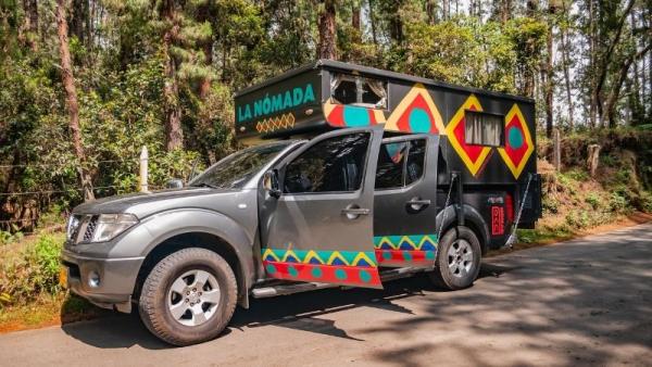
A special route requires special campers. These two vehicles are optimally adapted to the conditions of the tour.
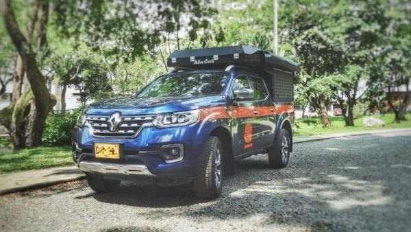
Calima Camper
The Calima Camper is a versatile 4x4 pickup truck with a specially designed camper module and a rooftop tent. This contemporary automatic vehicle offers a comfortable driving experience and is tailor-made for adventurers and nature enthusiasts alike.
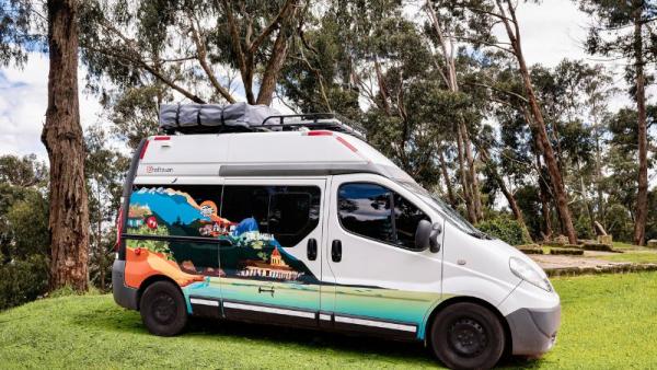
Poderosa Camper
Unleash the power of exploration with the Poderosa, a remarkable camper built on the foundation of the Renault Trafic Designed to elevate your camping experience to extraordinary levels, this camper combines convenience, comfort, and sustainable living into a single, exceptional package.
Route Wild Camping in Altiplano + Llanos
Day 1
Drive from Bogotá around Lake Tominé and visit the legendary Guatavita Lagoon, where the legend of El Dorado originates. After hiking around this unique crater lake, continue towards Macheta and look for a wild camping spot to spend the night. There are some thermal springs in the vicinity of Macheta that allow a motorhome to park in their facilities.
Day 2
Descend through the "Rainy Tunnel" of Machetá, pass the emerald producing village of Guateque, and turn north towards Yopal when you reach the Orinoco Plain. Look for accommodation near Yopal.
Day 3
Leave the flat landscape of the Llanos behind, drive directly from Yopal back up the mountains towards Labranzagrande, and spend the night in this untouched town at a wild camping spot.
Day 4
From Labranzagrande, ascend to 3,700 m, passing through the Toquilla highlands, which will take you directly to Aquitania on the shores of Lake La Tota, where you can spend the night on what is probably the highest white sand beach in the world.
Day 5
Enjoy the Tota Lake, take a tour, hike in the area.
Day 6
Passing through the traditional villages of Tota, Pesca, and Toca, return to Bogotá. Or make an additional 2-3 day stop in Villa del Leyva.
Your accommodation right there: with our campers including equipment and roof tent. With these two models, this adventure route will be particularly memorable.